
UPDATE: NOAA has corrected the typos in the illustrations at the new reanalysis intercomparison website.
# # # # #
NOAA opened two new blogs recently…and a new reanalysis intercomparison website, with a plethora of ENSO-related illustrations.
NOAA ENSO BLOG
I introduced the new NOAA ENSO blog at the end of the recent postThe 2014/15 El Niño – Part 10 – June 2014 Update – Still Waiting for the Feedbacks. With the length of that post, you may have missed it.
The new NOAA ENSO blog is hosted by Michelle L’Heureux and Emily Becker of the NOAA Climate Prediction Center (CPC) and Anthony Barnston of Columbia’s International Research Institute for Climate and Society (IRI). So far, the posts have been information-filled and geared toward readers without technical backgrounds.
Make sure you bookmark that new blog. Their next post is about the impacts of the evolving El Niño on U.S. weather this boreal winter.
NOAA HURRICANE BLOG
On May 29 this year, NOAA’s National Hurricane Center (NHC) published their introductory post at their new blog called the Inside the Eye. So far, that’s the only post. I look forward to their future posts.
NOAA REAL-TIME MULTIPLE REANALYSIS INTERCOMPARISON WEBSITE
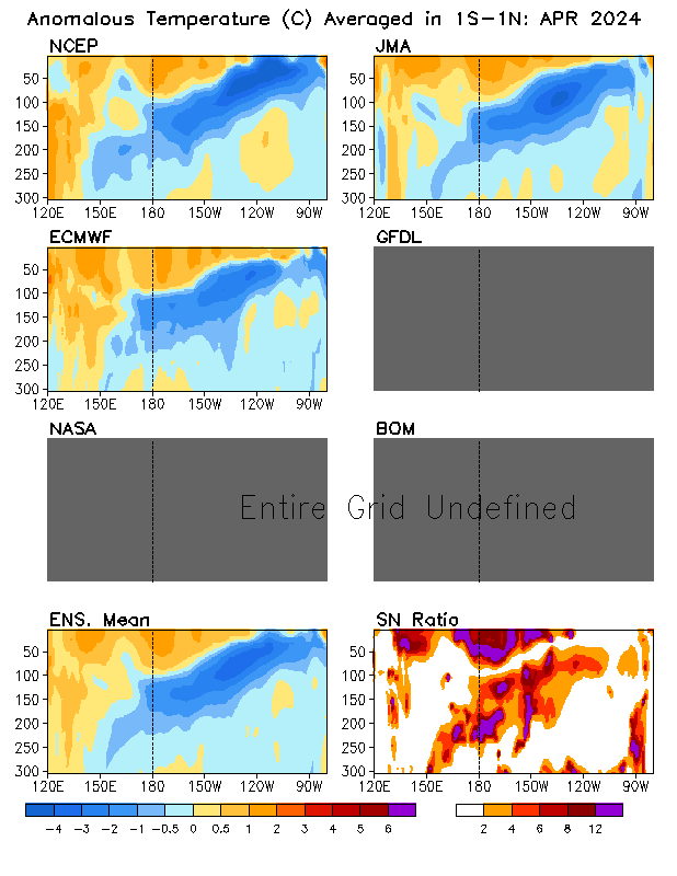
Back at the NOAA ENSO blog, Emily Becker introduced the new Real Time Multiple Ocean Reanalysis Intercomparison website in her June 5th post Details on the June 2014 ENSO discussion. They present the outputs of reanalysis models from NCEP, ECMWF , JMA , GFDL , NASA , BOM. Figure 1 is a sample illustration available from the new Real Time Multiple Ocean Reanalysis Intercomparison website. It shows the subsurface temperature anomalies for the equatorial Pacific (1S-1N) from those reanalyses. It can be found under the heading of SPATIAL MAPS and it’s identified as “Temperature anom. in 1S-1N (X-Z section): last month” there.

Figure 1
I’ve been using the similar pentadal (5-day) cross sections from the NCEP GODAS website for one my animations in my series of posts about the 2014/15 El Niño. (Latest example is here.)
I’m looking forward to trying to use the “Temperature anom. in 5N-10N (X-Z section)” to capture the off-equatorial Rossby wave returning warm leftover warm water from the 2014/15 El Niño as it heads back to the west at the end of the El Niño. Example: we can see the Rossby wave in the 1998 off-equatorial (5N-10N) cross sections following the peak of the 1997/98 El Niño. See Animation 1.

Animation 1
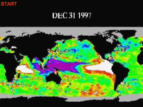
In the past, one of the best ways I’ve been able to show that off-equatorial downwelling Rossby wave is with an animation of sea level residuals from JPL. (See the animation here.)
You may also find the y-z sections of the Pacific informative. Figure 2 is a view, looking to the west, of the subsurface temperature anomalies in the eastern tropical Pacific (120W-90W) for May 1997. The warm anomalies at depth on the equator are caused by the downwelling Kelvin wave that initiated the 1997/98 El Niño.

Figure 2
A year later, May 1998, in Figure 3, we can see the impact of the upwelling Kelvin wave (which ended the 1997/98 El Niño) on the equatorial Pacific, and we can also see the well-formed off-equatorial Rossby at about 5N-10N as its preparing to return the leftover warm water back to the western tropical Pacific.

Figure 3
Animations of those and other cross sections and the maps available from the Real Time Multiple Ocean Reanalysis Intercomparison website should be helpful for an upcoming post about the delayed-oscillator theory of ENSO. IRI used to have a relatively simple presentation of the delayed-oscillator theory but I can no longer find it at their website, after their recent changes there.
Wander around the Real Time Multiple Ocean Reanalysis Intercomparison website. There are numerous things there worth exploring.
NOTE TO THE NOAA REAL-TIME MULTIPLE REANALYSIS INTERCOMPARISON WEBSITE
Temperature is spelled wrong in many of the illustrations available from your website.
Other than that, thanks for a great teaching tool. I look forward to using it.
Regards
Bob


Reblogged this on CraigM350 and commented:
Excellent tool. Thanks Bob.
If figures 1 and 2 could be combined and animated, it would really be an impressive 3D display. I think it’s hard for the average reader to grasp the volume of warmer-than-“normal” water moving around and at what speed it travels with static charts. Thanks for your continuing illumination of the ENSO process, Bob.
Question: Has anybody modeled how much does water viscosity impact the way the warm water fingers as it moves East? I have worked in the past with a much smaller scale situation in which viscosity differences fed a very well defined “finger”. However, I assume this current or wave is kept in place by the Coriolis force, right?
Thanks, Bob.
Regardless of what happens with ENSO 2014/15, no one will be able to claim a lack of information beforehand if they get slammed with a major weather system.
————————————
About the 2 blogs:
The ENSO one has new information and good graphics and, so far, they seem to be time relevant.
As for the hurricane one:
This, so far, doesn’t seem to be doing anything useful or, perhaps, I haven’t figured it out.
Cristina is still alive and there is almost nothing on “Inside the Eye” about it other than a link to the NHC’s active tropical cyclones page – and that is set on the Atlantic Ocean. Thus, this requires one to know to click the spot to get the Eastern Pacific. A Cristina link should go directly to the Pacific view. Also, they have a colored heading of “NHC Pacific” — that goes to a tweet feed. Someone may know why, but I don’t.
Fernando Leanme, the climate models used to hindcast and forecast global surface temperatures and the like cannot simulate many basic functions of ENSO. But with respect to specialized models, I am not well-versed in the capabilities of fluid-dynamic models. I do know of a blog where you could ask questions like that. It’s Isaac Held’s blog:
http://www.gfdl.noaa.gov/blog/isaac-held/
Isaac held is a senior scientist with the NOAA Geophysical Fluid Dynamics Laboratory.
Regards
Pingback: The 2014/15 El Niño – Part 11 – Is the El Niño Dying? | Bob Tisdale – Climate Observations
Pingback: The 2014/15 El Niño – Part 11 – Is the El Niño Dying? | Watts Up With That?
Thanks, I´ll go ask Isaac Held. I used to study oceanography, in those days we didn´t do much with water viscosities, but in the early 2000´s I got involved with some research types who showed me some really interesting videos they had been making in which viscosities played a huge role. Later, one of them asked me to look over a draft paper he had written to explain what they were seeing, and from what I saw, they couldn´t come close to explaining it in that 30 page draft. However, we were looking at fluid flows in a much smaller scale.
Unquestionably believe that which you said.
Your favorite reason appeared to be on the net the
easiest thing to consider of. I say to you, I
definitely get annoyed whilst folks consider worries that they just don’t know about.
You controlled to hit the nail upon the top and also
outlined out the entire thing without having side effect ,
other people could take a signal. Will likely be again to get
more. Thank you