
I was notified today of the rather remarkable plume of ENSO forecasts for 2015 from ECMWF (European Centre for Medium-Range Weather Forecasts). See their System 4 ENSO region sea surface temperature anomaly forecast webpage here.
Figure 1 presents the ECWMF plume of sea surface temperature anomaly forecasts for the NINO3 region (5S-5N, 150W-90W), with some of the runs reaching highs in November 2015 in the neighborhood of +4.5 deg C.

Figure 1
For those unfamiliar with them, see the map of NINO regions here.
Figure 2 show the plume for the NINO3.4 region (5S-5N, 170W-120W). Note how a couple of the runs reach beyond the upper +4 deg C extent of the y-axis.
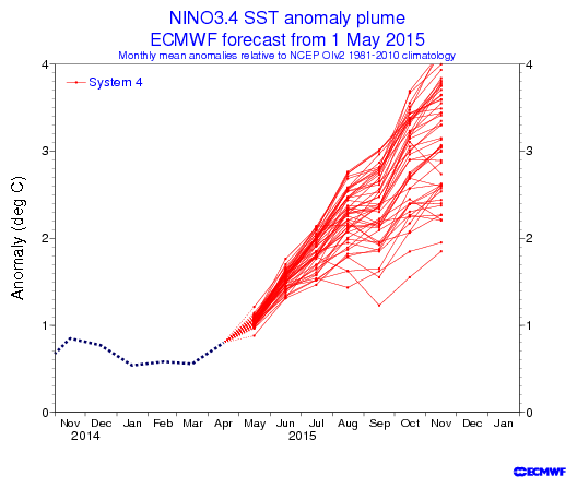
Figure 2
Now consider that NINO3.4 sea surface temperature anomalies peaked at +2.7 deg C in December 1997 in response to the 1997/98 super El Niño, and peaked at +2.8 deg C in January 1983 during the 1982/83 El Niño. See Figure 3, which is from the April 2015 Sea Surface Temperature (SST) Anomaly Update.

Figure 3
ARE NOVEMBER SEA SURFACE TEMPERATURE ANOMALIES OF +4.0 DEG C AND HIGHER IN THE NINO3.4 REGION PHYSICALLY POSSIBLE?
In the post Why Do El Niño and La Niña Events Peak in Boreal Winter?, we illustrated and discussed how and why the sea surface temperatures (absolute) of the NINO3.4 region mimic the seasonal cycle of, and come near to the values of, those in the western equatorial Pacific (5S-5N, 120E-165E) during a strong El Niño, like the one in 1997/98.
Based on the Reynolds OI.v2 data, the average November sea surface temperatures for the NINO3.4 region for the period of 1981-2010 is 26.64 deg C. That value serves as the November reference temperature for NINO3.4 sea surface temperatures anomalies.
Sea surface temperatures in the western equatorial Pacific (5S-5N, 120E-165E) are naturally warmer than those of the NINO3.4 region. The November sea surface temperature for the western equatorial Pacific in 2012 was 29.95 deg C; in 2013 the temperature there was 29.98 deg C; and, for 2014, it was 29.90 deg C. The average November temperature for the western equatorial Pacific for the past 3 years was about 29.94 deg C.
Let’s assume for a moment that the sea surface temperatures in NINO3.4 region did something very unusual in November 2015 and rose to that 2012-2014 average value of the western equatorial Pacific of 29.94 deg C. The November 2015 NINO3.4 sea surface temperature anomaly would be 3.3 deg C. That’s far short of 4 deg C.
Because someone’s bound to ask, in November 1997, the sea surface temperature for the western equatorial Pacific was 29.35 deg C, while the NINO3.4 region was remarkably similar at 29.31 deg C. And for November 1982, the sea surface temperature for the western equatorial Pacific was 29.08 deg C, while the NINO3.4 region was a little less at 28.81 deg C.
[My thanks for the heads-up, anonymous person.]
SOURCE
The Reynolds OI.v2 sea surface temperature data are available from the KNMI Climate Explorer.


Reblogged this on Centinel2012 and commented:
I would guess that “ALL” data is being manipulated to show in November December of this year that the World Climate is out of control because the CO2 level has gone over 400 ppm (for the first time ever) and this just happens to be the period of the UN COP21 conference in Paris where ‘they” will be looking for a world carbon tax that is mandatory on the EU and North America.
Hi Bob,
since several weeks NOAA/CFSv2 is predicting “Super El Niño” up to near 3,5, too. http://www.cpc.ncep.noaa.gov/products/CFSv2/imagesInd1/nino34Mon.gif
I remember the failed ENSO-predictions from ECMWF (and many others) in summer 2011, when El Niño-conditions were predicted and La Niña-conditions came… http://iri.columbia.edu/our-expertise/climate/forecasts/enso/archive/201112/SST_table.html
There was a difference near 2 K between predictions and observations.
My guess: Same procedure this year.
Cheers
Thanks, Bob. If the ECMWF model is correct we’ll probably have some El Niño warming to keep the pause going.
Not so fast! Have a look at last year’s april forecast plume. I notice a hiatus in the observations that was not visible in the forecast (sounds familiar?)
1997-1998 El Niño was a ‘hat trick’ period as both AMO and PDO were wicked warm…. I don’t think that is going to happen this year.
RSS
http://woodfortrees.org/plot/rss/from:1996.6/plot/rss/from:1996.6/trend
AMO
http://woodfortrees.org/plot/esrl-amo/from:1996.6
PDO
http://woodfortrees.org/plot/jisao-pdo/from:1996.6
Lets remember last years forecast for a super El Nino

All the hype from the experts
http://theweathercentre.blogspot.com.au/2014/03/could-next-super-el-nino-be-forming.html?m=1
which one of the enterage of models got the 2014 ENSO SST 3.4 correct
I notice a wide range in the forecast. So confidence must be low for an extreme event.
There wasn’t any triggering condition for super El Nino, so there is not going to be one. As I predicted correctly in 2011, also for this year there is not going to be any major El Nino. Northern troposphere cools rapidly prior major El Nino events, at least it has done it last 30 years (satellite maesurement era…)
http://earth.nullschool.net/#current/wind/surface/level/overlay=temp/equirectangular=-159.84,-0.23,512
Check out the trade winds
Hi Bob,
I am puzzled about the PDO trend, shown here,
http://www.woodfortrees.org/plot/hadcrut4gl/from:1987/to:2016/plot/hadcrut4gl/from:2002/to:2016/trend/plot/hadcrut3gl/from:1987/to:2016/plot/hadcrut3gl/from:2002/to:2016/trend/plot/rss/from:1987/to:2016/plot/rss/from:2002/to:2016/trend/plot/hadsst2gl/from:1987/to:2016/plot/hadsst2gl/from:2002/to:2016/trend/plot/hadcrut4gl/from:1987/to:2002/trend/plot/hadcrut3gl/from:1987/to:2002/trend/plot/hadsst2gl/from:1987/to:2002/trend/plot/rss/from:1987/to:2002/trend/plot/esrl-amo/from:2002/to:2016/trend/plot/jisao-pdo/from:2002/to:2016/trend
Is this possible?
HenryP, keep in mind the PDO has been standardized, which, in the case of the PDO, exaggerates its signal about 3 times. As opposed to the PDO trend only, plot the PDO data as well. It will dwarf the other datasets, because it’s not being presented in deg C like the others.
Thx. I think I know what you mean. I saw a piece in someonew comment earlier on.
Pingback: Eye of Siva » What you should read today
Going back to my point on AMO,
Buried deep in NOAA’s hurricane forecast: “The current and predicted 2015 suggest that the warm AMO signal might be absent this season.”
http://www.cpc.ncep.noaa.gov/products/outlooks/hurricane.shtml
New paper: Jet stream, NAO control when AMO flips:
The jet stream off the East Coast of the United States controls an important climate pattern in the Atlantic Ocean, a new study finds.
The jet stream’s swooping path over the Atlantic Ocean is steered by a fluctuating pressure system called the North Atlantic Oscillation (NAO). A positive NAO aims the jet stream toward Ireland, while a negative NAO sends the winds southward, in a pattern similar to the polar vortex of recent winters…..
Researchers now think the North Atlantic Oscillation, the atmospheric pattern that controls the jet stream, determines when this [AMO] ocean temperature flip takes place.
http://m.livescience.com/50998-jet-stream-controls-atlantic-climate-cycles.html
Alec aka Daffy Duck, thanks for the link.
It’s AMO Week, another paper, AMO flip:
ReportingClimateScience: “Global Climate On Verge Of Multi-Decadal Change”
From the University of Southampton
A new study, by scientists from the University of Southampton and National Oceanography Centre (NOC), implies that the global climate is on the verge of broad-scale change that could last for a number of decades.
The change to the new set of climatic conditions is associated with a cooling of the Atlantic, and is likely to bring drier summers in Britain and Ireland, accelerated sea-level rise along the northeast coast of the United States, and drought in the developing countries of the Sahel region. Since this new climatic phase could be half a degree cooler, it may well offer a brief reprise from the rise of global temperatures, as well as resulting in fewer hurricanes hitting the United States.
The study, published in Nature, proves that ocean circulation is the link between weather and decadal scale climatic change. It is based on observational evidence of the link between ocean circulation and the decadal variability of sea surface temperatures in the Atlantic Ocean.
Lead author Dr Gerard McCarthy, from the NOC, said: “Sea-surface temperatures in the Atlantic vary between warm and cold over time-scales of many decades. These variations have been shown to influence temperature, rainfall, drought and even the frequency of hurricanes in many regions of the world. This decadal variability, called the Atlantic Multi-decadal Oscillation (AMO), is a notable feature of the Atlantic Ocean and the climate of the regions it influences.”…
http://www.reportingclimatescience.com/news-stories/article/global-climate-on-verge-of-multi-decadal-change.html
Thanks again, Alec aka Daffy Duck.
Cheers
Alec aka Daffy Duck, now that I’ve read both links I believe they’re about the same paper.
Cheers.
I have been tracking the current Kelvin Wave and it is not going to do much as it is completing its journey and a back up wave does not appear to be happening in the short term. You can find my latest analysis at http://econintersect.com/pages/weather/weather.php?post=201505263025 I will be going into it in more depth this coming Monday. Bob Tisdale as usual has it right but I think one can go further and estimate the ONI almost by week going forward. One wonders about these computer models.
A few weeks ago I published in my weekly weather and climate update some Nordic studies that related to the NAO, AMO and sunspot cycles. Basically they concluded that about half of warming in their area is explained by those factors. You can find them if you dig through the site where I accumulate all the information that appears in my weekly articles. It is my way of writing a book but right now it is pretty disorganized. The url for that is http://econintersect.com/pages/weather/weather.php?post=static The Nordic research reminds me of this McCarthy Paper but brings sunspot cycles into the equation.
Global Warming I think is real but a careful analysis is fairly convincing that the rate of increase is much less than the IPCC models suggest. I am thinking it is about half of what is predicted for each RCP and the actual RCP may be more moderate than most people think due to economic and technology reasons. So the forecasts might be off by 75%.
Whatever it is it is and I mostly want to know what it really is going to be. I am still trying to find significant negative impacts from Warming. That is actually my focus as I am an economist. Other than sea level rise which may or may not be related to warming it is tough finding negative impacts on a global basis. But I have not completed my research yet but so far it seems like the major impacts will be a redistribution of population which is nothing new but is a problem when you have Nation States.
@Sig
there really has been no warming since the beginning of the century already.
Where ever I looked, I only see global cooling, e.g. :
Note that AGW proposes that minimum temps. should be rising, due to more CO2. That is not happening. In fact, on my random sample I got a perfect curve. So my conclusion from that (perfectness) of the curve is that everything is going natural.
There simply is no man made warming. None. Either immeasurably small or simply zero.