
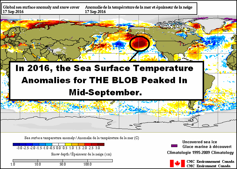
Animation 1 – Sea Surface Temperature Anomaly Maps from the CMC Environment Canada (September 17, 2016 and October 27, 2016)
The Blob was the name given to the area of elevated sea surface temperature anomalies in the eastern extratropical North Pacific. It formed in 2013, coupling with a ridge of high pressure that impacted weather patterns across North America into 2015. The Blob was the primary contributor to the reported record high global sea surface temperature anomalies in 2014, and contributed to the record highs in 2015 along with the 2015 portion of the 2014/15/16 El Niño. (See General Discussions 2 and 3 of my free ebook On Global Warming and the Illusion of Control – Part 1. Also see the series of posts about The Blob for additional general information.)
After a noticeable drop in the sea surface temperature anomalies for that region of the eastern extratropical North Pacific that lasted from late-2015 through mid-2016, the Blob reemerged in August, with the sea surface temperature anomalies peaking in September for 2016. See Animation 2, which includes daily sea surface temperature anomaly maps running from June 1, 2016 through today. (Depending on your browser, you may need to click on the animation.)
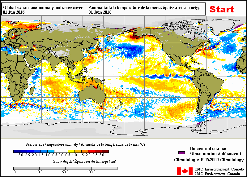
Animation 2 – Daily Sea Surface Temperature Anomaly Maps from the CMC Environment Canada (June 1, 2016 through October 27, 2016)
As shown, The Blob began to decay noticeably in early-to-mid October and has, now, basically disappeared from its normal location, though there are still elevated sea surface temperature anomalies in the eastern and central extratropical North Pacific.
We should expect a noticeable decline in the sea surface temperature anomalies this month in The Blob region, and in the North Pacific as a whole, when the monthly sea surface temperature data for October are published early next month.
Will The Blob disappear for good in the future or will it reappear annually during the boreal summer months as part of a new seasonal cycle? Only time will tell.


Pingback: Der Winter kommt früh nach Europa – Polarwirbel teilt sich! – wobleibtdieglobaleerwaermung
Thanks for the great animations.
Pingback: The Global Warming Policy Forum (GWPF)
Hi Bob…off topic,
I just noticed that the El Niño was 19 seasonal month periods long
According NOAA… record long,
http://www.cpc.ncep.noaa.gov/products/analysis_monitoring/ensostuff/ensoyears.shtml
Is 1950 the beginning of measured records?
Hi Alec. Yup, the 2014/15/15 El Nino was a tick longer than the 1986/87/88 El Nino…but shorter than the 1957/58/59 El Nino…according to the new ONI index.
The uncertainties of the sea surface temperature data for the NINO3.4 region grow during the WW2 years, so many researchers start their discussions in 1950.
Cheers.
57-59 has a two 3-month-season break in it, not continuous.
Making it a back-to-back El Niño http://www.cpc.ncep.noaa.gov/products/analysis_monitoring/ensostuff/ensoyears.shtml
Sorry, Alec. Don’t know how I missed that.
(sarc on) Eeek. El Ninos are getting stronger and longer…(sarc off)…according to NOAA’s much-modified Oceanic NINO Index.
Cheers.
Pingback: October 2016 Sea Surface Temperature (SST) Anomaly Update | Bob Tisdale – Climate Observations
Pingback: Something to Keep an Eye On – The Large Blue Ribbon of Below-Normal Sea Surface Temperatures in the North Pacific | Bob Tisdale – Climate Observations
Pingback: Something to Keep an Eye On – The Large Blue Ribbon of Below-Normal Sea Surface Temperatures in the North Pacific | Watts Up With That?
Pingback: November 2016 Sea Surface Temperature (SST) Anomaly Update | Bob Tisdale – Climate Observations
Pingback: Deep Ocean Warming in Degrees C | Bob Tisdale – Climate Observations
Pingback: Deep Ocean Warming in Degrees C |