GENERAL NOTES – BOILERPLATE
The February 2014 Reynolds OI.v2 Sea Surface Temperature (SST) data through the NOAA NOMADS website won’t be official until Monday, March 10,, 2014. Refer to the schedule on the NOAA Optimum Interpolation Sea Surface Temperature Analysis Frequently Asked Questions webpage. The following are the preliminary Global and NINO3.4 SST anomalies for February 2014 that the NOMADS website prepares based on incomplete data for the month. I’ve also included the weekly data through the week centered on February 26, 2014, but I’ve shortened the span of the weekly data. As noted in the recent mid-April 2013 update, I’ve started using February 2001 so that the variations can be seen AND so that you can see how “flat” global sea surface temperature anomalies have been since then.
The base years for anomalies are 1971-2000, which are the standard base years from the NOAA NOMADS website for this dataset.
PRELIMINARY MONTHLY DATA
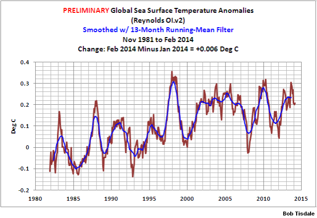
The preliminary global sea surface temperature anomalies are presently at about +0.2 deg C. Based on the preliminary data, they basically remained the same (an increase of about +0.01 deg C) since January.
Monthly Global SST Anomalies
######################
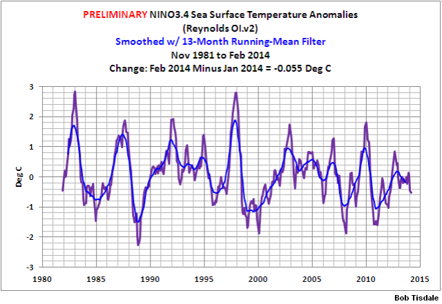
The sea surface temperature anomalies of the NINO3.4 region in the eastern equatorial Pacific (5S-5N, 170W-120W) are a commonly used index for the strength, frequency, and duration of El Niño and La Niña events. See the illustration here for the location of the NINO3.4 region. Based on the preliminary data, February 2014 NINO3.4 sea surface temperature anomalies are below zero (about -0.52 deg C). The threshold for an El Niño is considered to be warmer than or equal to +0.5 deg C and for a La Niña, it’s cooler than or equal to -0.5 deg C. So the reading of -0.52 deg C indicates the tropical Pacific is at the threshold of La Niña conditions. Also refer to the weekly data that follows.
Monthly NINO3.4 SST Anomalies
######################
WEEKLY DATA
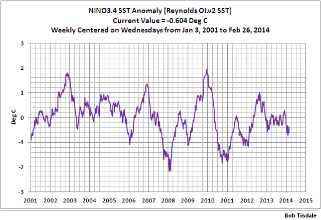
Weekly NINO3.4 region (5S-5N, 170W-120W) sea surface temperature anomalies for the week centered on February 26, 2014 continue to be cooler than the -0.5 deg C threshold of La Niña conditions. The weekly NINO3.4 sea surface temperature anomalies were approximately -0.6 deg C.
Weekly NINO3.4 SST Anomalies
######################
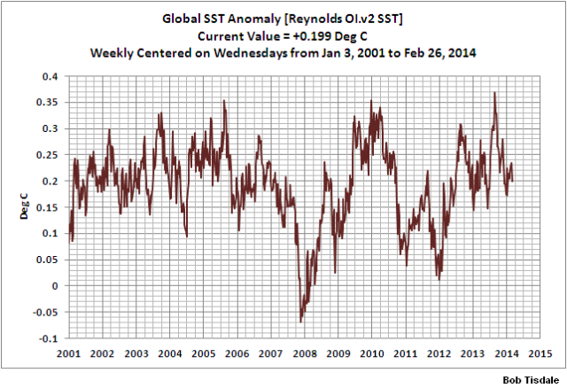
The weekly Global sea surface temperature anomalies have cooled a little over the past week. They are presently about +0.2 deg C.
Weekly Global SST Anomalies
######################
INTERESTED IN LEARNING MORE ABOUT THE EL NIÑO AND LA NIÑA AND THEIR LONG-TERM EFFECTS ON GLOBAL SEA SURFACE TEMPERATURES?
Why should you be interested? Sea surface temperature records indicate El Niño and La Niña events are responsible for the warming of global sea surface temperature anomalies over the past 30 years, not manmade greenhouse gases. I’ve searched sea surface temperature records for more than 4 years and ocean heat content records for more than 3 years, and I can find no evidence of an anthropogenic greenhouse gas signal in either dataset. That is, the warming of the global oceans has been caused by naturally occurring, sunlight-fueled, coupled ocean-atmosphere processes, not anthropogenic greenhouse gases.
Last year I published an ebook (pdf) about the phenomena called El Niño and La Niña. It’s titled Who Turned on the Heat? with the subtitle The Unsuspected Global Warming Culprit, El Niño Southern Oscillation. It is intended for persons (with or without technical backgrounds) interested in learning about El Niño and La Niña events and in understanding the natural causes of the warming of our global oceans for the past 31+ years. Because land surface air temperatures simply exaggerate the natural warming of the global oceans over annual and multidecadal time periods, the vast majority of the warming taking place on land is natural as well. The book is the product of years of research of the satellite-era sea surface temperature data that’s available to the public via the internet. It presents how the data accounts for its warming—and there are no indications the warming was caused by manmade greenhouse gases. None at all.
Who Turned on the Heat? was introduced in the blog post Everything You Ever Wanted to Know about El Niño and La Niña… …Well Just about Everything. The Free Preview includes the Table of Contents; the Introduction; the beginning of Section 1, with the cartoon-like illustrations; the discussion About the Cover; and the Closing.
Please buy a copy. (Credit/Debit Card through PayPal. You do NOT have to open a PayPal account. Simply scroll down to the “Don’t Have a PayPal Account” purchase option. It’s only US$8.00 marked down to U.S.$5.00.
SOURCE
The Sea Surface Temperature anomaly data used in this post is available through the NOAA NOMADS website:
http://nomad1.ncep.noaa.gov/cgi-bin/pdisp_sst.sh
or:


Loschmidt was the brilliant 19th century physicist who was the first in the world to successfully estimate the size of air molecules – within a factor of 2 or so anyway. We can assume Loschmidt thought about what those molecules did, and, with the knowledge of the fact that gas molecules were far smaller than the space between them, the world saw the beginning of Kinetic Theory being applied to “ideal” gases with documented assumptions that I encourage you all to read, because Kinetic Theory was successfully used by Einstein and others, and from it we can derive the well known ideal gas laws. We can also derive (in just two lines) the magnitude of the so-called dry adiabatic lapse rate without using those gas laws or any pressure data.
It’s not hard to visualise what Loschmidt did, namely molecules moving around at random and colliding with others rather like billiard balls. When they collide they share their kinetic energy, and as a result, we see diffusion of kinetic energy which results in a tendency towards equal temperatures in a horizontal plane. We have all observed such diffusion in our homes when warmth from a heater spreads across the room.
But, when those molecules move in free frictionless flight between collisions the assumptions of kinetic theory include the “classical treatment” of their dynamics, noting that “because they have mass the gas molecules will be affected by gravity.” And so Newtonian mechanics tell us that the sum of kinetic energy and gravitational potential energy remains constant.
But, as a gas spontaneously approaches thermodynamic equilibrium it is approaching a state in which there are no unbalanced energy potentials. That state is isentropic, having (PE+KE)=constant at all heights, and this means that KE varies and, as Kinetic Theory tells us, temperature also varies in proportion to the mean kinetic energy of the molecules.
It does not matter that the final state is never completely materialised, and so entropy will still be increasing. We are considering what happens as we approach a limit, just as in calculus. Entropy will keep increasing until that limit is achieved, but it never is because, with a new day dawning more solar energy is added causing a significant disturbance to the process and moving it further away from equilibrium. Never-the-less, by the following night if there are calm conditions, the state of thermodynamic equilibrium will again be approached.
Over the life of the planet the temperature gradient has obviously evolved on all planets with significant atmospheres, and it also occurs in sub-surface regions such as Earth’s outer crust and inside the Moon.
The empirical evidence is that Loschmidt was right and that Maxwell erred on just this particular issue wherein molecular studies were perhaps not his specialty. The huge significance of this is that there is no need for any greenhouse radiative forcing to explain planetary atmospheric and surface temperatures. These cannot be explained at all by radiation calculations – only by the gravity gradient. The trillion dollar question is thus, was Loschmidt right?
D o u g C o t t o n: Please refrain from introducing obscure topics here. Thanks.
http://www.rte.ie/news/special-reports/2014/0305/600255-global-landmarks-under-threat-from-climate-change/
just thought you might like to know how Evil you are. In 2000 years folks are going to be really pissed off. hahaha. enjoy a laugh.
regards
nevket240, do they want me to worry about something 2000 years from now, or are they putting sea level rise in perspective?
nevket240, it is stupid to project 2000 years into the future. I would hope by then, we would be terraforming Mars and the Moon and could use all of Earth’s extra water to make those places habitable.
Bob, can you answer a couple of questions concerning your prior state / history of ENSO?
1 – You have said in the past the the La Nina in 97 cleared the skies for the 98 El Nino. Do you know or have records showing what generally happens in an extended La Nada (if that is the correct term for NINO3.4 region between -0.5 & +0.5)?
2 – The above La Nada looks to be going on for around 14 months. In the past (chart above) I only see one other long lull (1991 timeframe, which also a some puff of ash going on). Do you find any other periods with this condition?
Thanks, and will check back to see your comments.
Good luck with your additional job.
Did you see where is predicting a strong El Nino? http://news.yahoo.com/comes-el-nino-good-news-us-weather-woes-142354512.html
Retired Engineer John, it’s Trenberth predicting the possibility of a strong El Nino, not NOAA. Interesting. Trenberth’s starting to sound like Hansen, back when Hansen was predicting super El Ninos almost every year.
DD More says: “You have said in the past the the La Nina in 97 cleared the skies for the 98 El Nino.”
I believe you misinterpreted what I said. The 1997/98 El Niño was followed by the 1998-01 La Niña. During La Niña events, there is less cloud cover due to the stronger trade winds. See the introduction post here:
DD More says: “Do you know or have records showing what generally happens in an extended La Nada (if that is the correct term for NINO3.4 region between -0.5 & +0.5)?”
Nope. Most of the discussions from NOAA, BOM, etc., deal with what happens during El Niño OR La Niña events, not ENSO neutral periods.
DD More says: “The above La Nada looks to be going on for around 14 months. In the past (chart above) I only see one other long lull (1991 timeframe, which also a some puff of ash going on). Do you find any other periods with this condition?”
A while back, I created a table of El Niño and La Niña events similar to how NOAA presents its ONI data. See the post here:
There are a couple of multiyear periods without “official” El Niño or La Niña events.
Regards
You were right on the 97/98 and post La Nina, I just got confused on my timing. That chart was just what I was looking for. Thanks much.
So are we in a la nina now? Why do we only hear about this upcoming el nino from all the alarmists? The ocean temps look like a la nina to me. Is it right that there is a 3 to 6 month lag in temperatures with la ninas? Thus, can we expect the temperatures to continue to fall globally in the next few months or so (as they have been doing for the past three months already)?
Jeff says: “So are we in a la nina now?”
Based on the sea surface temperatures of the NINO3.4 region, we’re experiencing La Nina conditions. But it is not an “official” La Nina.
Jeff says: “Why do we only hear about this upcoming el nino from all the alarmists?”
Because of what’s going on below the surface of the equatorial Pacific. See the following animation. The positive anomalies working their way eastward along the equator are called a downwelling Kelvin wave. (The last cell in the animation appears to be a computer glitch.)
http://www.cpc.ncep.noaa.gov/products/analysis_monitoring/enso_update/wkxzteq.shtml
Kelvin waves typically take a few months to cross the Pacific, and this one looks like it might be strong enough to initiate an El Nino.
Jeff says: “Is it right that there is a 3 to 6 month lag in temperatures with la ninas? Thus, can we expect the temperatures to continue to fall globally in the next few months or so (as they have been doing for the past three months already)?”
It generally takes 3 to 6 months for global surface temperatures to respond fully to major changes in the state of the sea surface temperatures of the equatorial Pacific. But we haven’t really seen any major changes over the past year, so the global responses to the minor changes may simply be overcome by “weather noise”.
There is a real battle going on between the gyre at the just North of the equator off the South American coast and the warm flow from the Eastern Pacific. The upwelling is giving the gyre enough power to pump large quantities of cold lighter weight salt water to block the warm water. The warm water is being forced down as shown on the NOAA animation. As long as the gyre remains this strong, we may continue to see the warm flow blocked from the surface. Have you looked at the NRL salt animation on WUWT?
Retired Engineer John, there’s a chunk of cool water in the eastern tropical Pacific and a chunk of warm moving eastward along the equator. It’ll be interesting to watch what happens.
Regards
Also keep in mind two things: one the cold water moving west has been expanding during that time. It’s all the way to the 170 degree lat. Two, the warm water pool is actually getting cooler. I agree with retired engineer bob, that the warm water is being pushed down. From my untrained eyes, the cold water seems to be winning.
I still don’t see how an el nino forms here. If one should it looks like it’ll be a weak one.
Bob,
I know you don’t like to make predictions, but are there any particular analogous years to this spring in regards to ENSO development? I know there have been some vague similarities between the weather pattern of 1917/18 and this current winter that Joe D’Aleo has noticed. I’ve also noticed that when big Kelvin waves like the current one just about to surface in the equatorial Pacific, this early in the year, has in the past indicated a stronger warm episode. Any thoughts you have on this would be appreciated since it is kind of your area of expertise. (ENSO). Thank you!
Brian S, at this time of year, it is very difficult for even the models to forecast what’s going to happen.
There is a downwelling Kelvin wave working its way eastward, but I don’t know that it’s especially early. Here’s a subsurface temperature anomaly plot from GODAS for Feb 2014:

The 1997/98 El Niño was much further along in its formation by Feb 1997:

But the 2009/10 El Niño was lagging 2014 in its formation:

Then again, there was a relatively large supply of warm water in the western equatorial Pacific in Feb 2012, but that year was ENSO neutral:

I suspect that didn’t help.
The source of those plots is here:
http://www.cpc.ncep.noaa.gov/products/GODAS/mnth_gif/xz/
Regards
Excuse me, Bob
Why did you choose 13-month running-mean filter?
How about 11-month or any other?
Wu, I don’t recall looking at an 11-month filter before. Thanks for asking.
The following is the South Atlantic sea surface temperature anomaly data with 11-month, 12-month and 13-month filters. I’ve used the South Atlantic because it’s volatile. For the purposes of minimizing the seasonal component, there’s no appreciable difference between the three but the 11-month seems to leave in a bit of the seasonal component at times.

Bob – I keep puzzling over the big drop of global T in 2008, presumably a big La Nina, but do we know much about what initiated that? Have you written about it?
Peter Taylor, if your question relates to why did global surface temperatures appear to drop so excessively in response to the 2007/08 La Nina, my answer is, I haven’t a clue. If your question is what initiated the 2007/08 La Nina, my answer would be the 2006/07 El Nino. If your question is why was the 2007/08 La Nina so strong in response to a moderate 2006/07 El Nino, I suspect the drop in the sea surface temperature of the Southern Ocean from 2006 to 2008 has played a role.

And I also suspect that the drop in the sea surface temperatures of the Southern Ocean from 2006 to 2008 has also played a role in the shift toward La Nina domination since then.
Regards