
After many months of borderline El Niño conditions in the tropical Pacific, yesterday NOAA finally declared an El Niño was occurring. See Anthony Watts’s post NOAA Claims: ‘Elusive El Niño arrives’ – the question is, ‘where’? at WattsUpWithThat. It includes a number of items like the announcement by NOAA, NOAA’s El Niño decision flowchart, and a couple Twitter exchanges.
Emily Becker’s post March 2015 ENSO discussion: El Niño is here at the NOAA ENSO blog expands on many of the discussions. It includes the following (click on the links for illustrations and further discussion):
What tipped us over the line?
What’s different this month? For starters, it’s the second month in a row with a negative value for the Equatorial Southern Oscillation Index (EQSOI, -0.5 for February), one indicator of a weakened Walker Circulation. Also, the pattern of below-average rainfall in the central Pacific, which was very inconsistent with El Niño, recently transitioned to near-average rainfall (as indicated by outgoing longwave radiation). The increased rainfall we were seeing in the western equatorial Pacific continued.
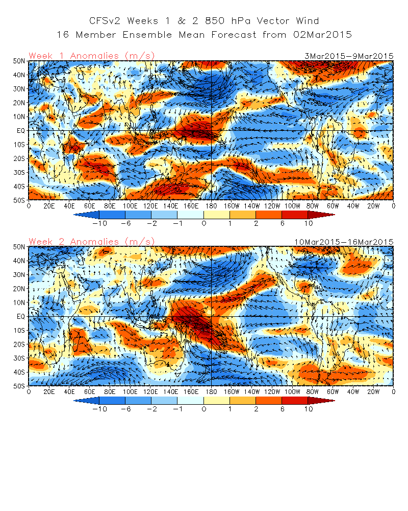
Late January and February saw a couple of westerly wind bursts over the central tropical Pacific, and the forecast for the first two weeks of March suggests these winds will continue. When the winds in this region turn more westerly, they can encourage movement of warmer surface waters eastward and either trigger or strengthen downwelling Kelvin waves, leading to warmer SST anomalies in the central and eastern parts of the tropical Pacific.
Also, over the last month, we saw an increase in sub-surface heat content and the growth of a moderate downwelling Kelvin wave. This suggests that there is likely to be a continuing source of warmer-than-average ocean temperatures for the next couple of months, potentially encouraging the continuation of the weak atmospheric coupling.
On the other hand—showing that we are still very close to the borderline—the Tahiti – Darwin SOI, another indicator of ENSO (though farther off the equator compared to the EQSOI), was +0.2 for February. Also, the “near average” rainfall in the central Pacific combined with above-average rainfall in the western Pacific is not a strong indication of El Niño conditions. As we’ve discussed before, a strong signal would be above-average rainfall in the central and eastern Pacific, and below-average rainfall over Indonesia.
Going forward, we will need to continue to monitor whether pressure and rainfall across the equatorial Pacific remain consistent with El Niño conditions.
But what I haven’t found is NOAA noting that they were a month away from highlighting the 3-month “seasons” since September-October-November 2014 as a “warm event”, an El Niño, on their Oceanic NINO Index (ONI). My Figure 1 is a highlighted and edited screen cap of the NOAA ONI webpage dated March 5, 2015.

Figure 1
Basically, the sea surface temperatures of the NINO3.4 region have to stay at or near the +0.5 deg C threshold of an El Niño for only a few more weeks in order for there to have been El Niño conditions for 5 consecutive over-lapping seasons, which would then be highlighted in red as an El Niño on the NOAA ONI webpage.
And based on the strength of the most recent downwelling (warm) Kelvin wave, that’s very likely to occur. See Animation 1, which is a cross section of the subsurface temperature anomalies of the equatorial Pacific from the NOAA Pacific Temperature Depth Anomaly Animation webpage.
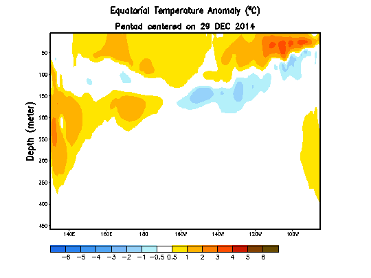
Animation 1
In other words, NOAA was eventually going to have to declare an El Niño has been occurring since last boreal autumn because their Oceanic NINO Index is a month away from showing one. In some respects, the announcement is more hindcast than forecast.
We’ll discuss in a post next week a number of other indicators and compare the data this year to last year. Sorry, I don’t have the time to do it today.
The other posts in this 2014/15 El Niño series can be found here.


Thanks, Bob. Much appreciated.
Thanks, Bob.

The current MEI slight El Niño conditions have been in a down slope since their beginning.
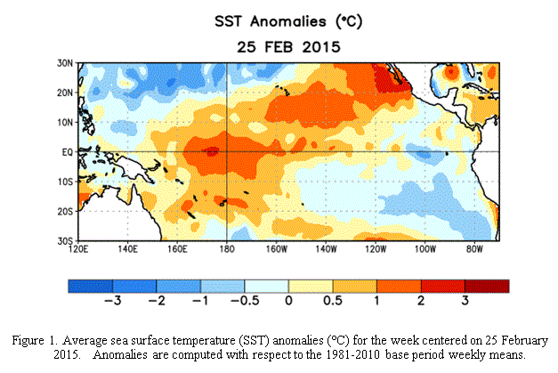
And the current Tropical Pacific SST map doesn’t show an ongoing El Niño.
From ENSO Diagnostic Discussion – 5 March 2015, at http://www.cpc.ncep.noaa.gov/products/analysis_monitoring/enso_disc_mar2015/ensodisc.html
If they declare an El Nino they have to admit California isn’t in for a centuries long disastrous drought, yet. Decisions decisions….
It is a marginal Modoki Type II
http://econintersect.com/pages/weather/weather.php?post=201503094543
I went through the data and the Spring and Summer impacts of an El Nino in the Northern Hemisphere are essentially nothing. It is not clear what the impacts of a Modoki would be but I provided one reference to that. It is more likely to impact the Western Pacific than the U.S. but marginally.
So the question remains why the rush when as Bob Tisdale has stated the ONI for March will be above 0.5 because of the current Kelvin Wave? Then at least one half of the criteria for declaring an El Nino would be technically satisfied and I would owe Bob lunch.
Someone must have put pressure on them. It seems like a silly way to tarnish your professional reputation by cutting corners to define an event which this time of year has no significance.
The usual advice is to follow the money and I suggest that might apply to this situation and I am thinking project funding.
Bob,
thought you might be interested.
http://www.zerohedge.com/news/2015-03-17/pam-was-so-big-she
regards
Thanks, nevket240. We’ll have to keep watching to see if it unfolds.
Pingback: March 2015 ENSO Update – Will the 2014/15 El Niño Become the 2014/15/16 El Niño? | Bob Tisdale – Climate Observations
Pingback: March 2015 ENSO Update – Will the 2014/15 El Niño Become the 2014/15/16 El Niño? | Watts Up With That?
Pingback: March 2015 ENSO Update – Will the 2014/15 El Niño Become the 2014/15/16 El Niño? | I World New
Pingback: The 2014/15 El Niño Series Posts | Bob Tisdale – Climate Observations
Pingback: April 2015 ENSO Update – Australia’s BOM and the JMA Declare an El Niño and With Them Comes the Typical Nonsense from an Expert Source | Bob Tisdale – Climate Observations
Pingback: May 2015 ENSO Update – Australia’s BOM and the JMA Declare an El Niño and With Them Comes the Typical Nonsense from an Expert Source | Watts Up With That?